Experimental Facilities
- Geotechnical Centrifuge
A centrifuge device is an experimental apparatus that can reproduce phenomena
similar to those in real life within a small-scale model. Structures such
as embankments, roads, dams, retaining walls, tunnels, and foundations
are all very large constructions. Therefore, in order to experimentally
investigate their stability against earthquakes, heavy rain, floods, and
other factors, it is essential to use scaled-down models (scaled models)
rather than real-life sizes. However, it is known that the soil that makes
up the ground does not behave in the same way within a scaled model as
it does in reality. This is where the centrifuge loading device is used.
For example, a scaled model that is 1/50th of the actual size is subjected
to a centrifuge acceleration of 50 times the force of gravity (50g). In
this condition, by applying vibrations that simulate seismic motion or
sprinkling water to simulate heavy rain, the model can reproduce behaviors
similar to those of the real object, even within a small model.
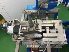
・Specifications
We own a small beam-type centrifuge with a rotational radius of approximately 1.6 meters. The platform, measuring 60cm×50cm, supports a model soil container that is approximately 50 cm in width and 30 cm in depth, and can provide a maximum centrifugal acceleration of 100g.
・Measurement
Phenomena occurring inside the model are measured using up to 44 sensors, including accelerometers, pore pressure transducers, displacement gauges, strain gauges, load cells, and moisture meters installed in the model. The data is recorded by a PC located within the centrifuge. Additionally, the system includes several small CCD cameras and GoPro cameras, which capture images and videos used for image analysis, such as PIV (Particle Image Velocimetry) and SfM (Structure from Motion) analyses.
・Mechanical Shaking Table
By utilizing a mechanical shaking table with a maximum acceleration of 25g, experiments on dynamic phenomena of the ground, such as liquefaction, ground shaking, slope failure, and settlement or tilting of structures, under strong seismic motions (referred to as Level 2 seismic motion), can be conducted.
・Rainfall Generation System
The system is equipped with a rainfall generation device capable of reproducing heavy rainfall of up to 100mm/h at full scale, enabling experiments on phenomena such as slope failure during heavy rain or the infiltration of rainwater into the ground.
・Others
The laboratory also utilizes a cone penetration testing device and a bender element to profile soil strength characteristics. Additionally, a laser profiler is used to obtain high-precision 3D DEM of the model's surface.
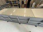
- Large-scale Piping Experiment Device
We are working on understanding the piping phenomenon in river embankment
foundation soils through experiments using a large soil box with dimensions
of 4.8m in length and 0.9m in depth. In these experiments, the amount of
sand used exceeds 3,000kg, and by using a transparent acrylic embankment,
we can track the development of the piping shapes that appear on the surface
of the foundation soil.
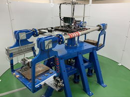
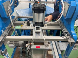
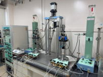
- Pneumatic Servo Cyclic Triaxial Testing Device
The pneumatic servo cyclic triaxial testing device is primarily used to investigate the liquefaction strength characteristics of sandy soils. It applies deviatoric stress using a pneumatic servo system. Most soils below the groundwater level are completely saturated with water and contain no air, and liquefaction of the ground typically occurs in saturated soils. This device is used to examine the liquefaction strength characteristics of saturated sandy soils during earthquakes, accurately controlling the deviatoric stress and precisely measuring pore water pressure and strain during repeated loading.
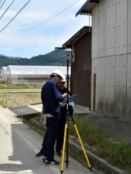
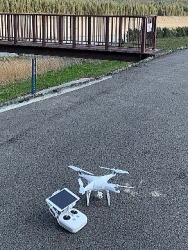
- Network-based RTK-GNSS and Camera Drones
The network-based RTK-GNSS is a device that efficiently performs real-time surveying with an accuracy of 1 to 2 cm by using correction data created from electronic reference points distributed across the country (RTK: Real-Time Kinematic). This device is portable and can obtain high-precision coordinates of arbitrary points on-site, even when used alone. Additionally, drones can capture multiple photographs from the air, and 3D DEMs (Digital Elevation Models) can be generated through SfM (Structure from Motion) analysis. Since the GPS on drones has lower precision, the accuracy of the DEM can be significantly improved by using RTK-GNSS to precisely capture the location information of control points previously installed on the ground. In our laboratory, we use DEMs obtained with this technology to study the temporal deformation behavior of river embankments, as well as to measure surface shapes after disasters (such as slope failures and soil flow after liquefaction).